I want to sink some time into the club-soccer book.
So you're going to get a List X In Y Minutes quiz. Mental Floss, using the 2010 Census, gives you ten minutes to name the most populated cities in America.
Specifically, the largest city beginning with each letter of the alphabet. (My score: 16. I don't know how in blazes I came up with the answer for X.)
Or, if naming those cities is too easy, head to Sporcle and name the 50 largest cities in 2009... that end in 'ville'. You have seven minutes for that. If that seems short, don't fret it. You could have 70 minutes and you would not get them all. (I was brazenly looking through an atlas the whole time and only managed 24.)
Or you can spend 20 minutes trying to work through as many of the 7,500 largest cities on Earth as you can. To make it interesting, the cities are grouped by population into chunks of 25. Give one answer in the group, and you're given credit for the entire group. That makes for 300 groups you have to hit. Tagging one of the 6.7 million-plus cities is child's play. Hitting the mid-64,000 group, that's a bit harder. (Haven't tried this one.)
Showing posts with label geography. Show all posts
Showing posts with label geography. Show all posts
Sunday, July 17, 2011
Tuesday, July 12, 2011
All Points Bulletin
Everywhere is the center of the universe. Or at least it seems that way sometimes. No matter how isolated a town is from the rest of the world, they're always going to think about places and events in relation to where they are. Any city of any size will, however rightly or wrongly, think of itself as the hub of the county, the region, the state, the country, the world. Everything goes through them (solve for value of "everything").
As such, it will sometimes happen that one of these places will construct a road sign or a compass or a globe or some sort of large-scale 'You Are Here' sign.
For many countries, this takes the form of something Wikipedia has blanket-referred to as Kilometer Zero. Kilometer Zero is a marker or monument located somewhere in the country- typically the capital, but not always- from which all distances in the country are intended to be measured.
France's Kilometer Zero is this marker in front of the Cathedral of Notre Dame. Spain's is this marker in Madrid's Puerta del Sol. Indonesia's is this building on the west coast of the island of Sabang. Ukraine's is this monument in Kiev. Canada's is the western end of the Trans-Canada Highway on Vancouver Island, British Columbia.
The United States has a Kilometer Zero, called Zero Milestone. It was created in 1923, sitting within eyesight of the White House. However, in practice, it only serves as Kilometer Zero for Washington DC. Everybody else does their own thing. Mile markers might measure the distance to the county line or state line. Highway distance signs have no definitive answer I could hunt down. When looking for what a sign signifying distance to any given city uses as its point of reference, I came up with the post office (though which one?), some other public building, 'a point close to the center of town', and 'the edge of town'. You're on your own for that one.
Italy's current Kilometer Zero is the top of Capitoline Hill in Rome. Back in the days of the Roman Empire, though, they used the Milliarium Aureum, a golden milestone (that's the translated Latin) with gilded bronze finishing. It's thought, but not confirmed, that the Milliarium Aureum had listed on it distances to all the major cities in the Roman Empire (hence the term 'all roads lead to Rome').
Not many modern Kilometer Zeroes list city distances. That role has largely been relegated to signs that look like this one at Lake Louise Ski Resort in Alberta:
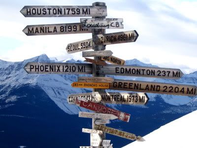 (source: travelandtransitions.com)
Those are the fun ones, incidentally.
But the undisputed Kilometer Zero champion has to be- and if you've ever driven in South Dakota, you know it already- Wall Drug. It's not every tacky tourist trap that can get itself a sign in Amsterdam. Or Antarctica. Or Bagram AFB in Afghanistan. Or a sign that tells you about their other signs in Kenya and London.
Or this blog.
It's 676 miles to Wall Drug, South Dakota.
As such, it will sometimes happen that one of these places will construct a road sign or a compass or a globe or some sort of large-scale 'You Are Here' sign.
For many countries, this takes the form of something Wikipedia has blanket-referred to as Kilometer Zero. Kilometer Zero is a marker or monument located somewhere in the country- typically the capital, but not always- from which all distances in the country are intended to be measured.
France's Kilometer Zero is this marker in front of the Cathedral of Notre Dame. Spain's is this marker in Madrid's Puerta del Sol. Indonesia's is this building on the west coast of the island of Sabang. Ukraine's is this monument in Kiev. Canada's is the western end of the Trans-Canada Highway on Vancouver Island, British Columbia.
The United States has a Kilometer Zero, called Zero Milestone. It was created in 1923, sitting within eyesight of the White House. However, in practice, it only serves as Kilometer Zero for Washington DC. Everybody else does their own thing. Mile markers might measure the distance to the county line or state line. Highway distance signs have no definitive answer I could hunt down. When looking for what a sign signifying distance to any given city uses as its point of reference, I came up with the post office (though which one?), some other public building, 'a point close to the center of town', and 'the edge of town'. You're on your own for that one.
Italy's current Kilometer Zero is the top of Capitoline Hill in Rome. Back in the days of the Roman Empire, though, they used the Milliarium Aureum, a golden milestone (that's the translated Latin) with gilded bronze finishing. It's thought, but not confirmed, that the Milliarium Aureum had listed on it distances to all the major cities in the Roman Empire (hence the term 'all roads lead to Rome').
Not many modern Kilometer Zeroes list city distances. That role has largely been relegated to signs that look like this one at Lake Louise Ski Resort in Alberta:
Those are the fun ones, incidentally.
But the undisputed Kilometer Zero champion has to be- and if you've ever driven in South Dakota, you know it already- Wall Drug. It's not every tacky tourist trap that can get itself a sign in Amsterdam. Or Antarctica. Or Bagram AFB in Afghanistan. Or a sign that tells you about their other signs in Kenya and London.
Or this blog.
It's 676 miles to Wall Drug, South Dakota.
Monday, May 16, 2011
Against The County Judge, They Held A Grudge, But Not Forevermore
In order to have something named after you, usually it takes you having done something that someone finds worthy. Unless you name stuff after yourself. Hi, Donald Trump. Hi. Robert Byrd. Or unless someone does it as an insult. Hi. Dave Barry. But we're getting away from the point. Generally, if you have something named for you, it's an honor.
And the bigger the thing named after you, the more of an honor it is. There are plenty of buildings to go around, plenty of streets to go around. After that, though, scarcity starts to take hold, and for cities and up, not only are there only so many places, it gets progressively more difficult to rename something. So when you get up into counties, states, and especially countries, you want to be very careful in who you choose to honor.
States and countries are too easy to look up. So we'll do counties.
Plenty of counties have been named for Presidents. 24 Presidents have counties; the leader is George Washington with 31, followed by Thomas Jefferson with 24 (one of them encompassing the bulk of my hometown), and Andrew Jackson with 21. Why only 24? Note once again the difficulty and inertia in renaming something this large. The most recent President to carry a county name is Warren Harding. That means nothing for Hoover, Franklin D. Roosevelt, Eisenhower, Roosevelt, Truman, Kennedy, Lyndon Johnson, Nixon, Ford, Carter, Reagan, Bush 41, Clinton, Bush 43 or Obama.
Here are three of the others...
BREMER COUNTY, IOWA
Bremer County, county seat Waverly, is named for Swedish novelist Fredrika Bremer. She was raised to be a member of the Swedish aristocracy; however, she found this too patronizing and too unfair to women that were not as fortunate. This actually included herself; for all the money that surrounded her, the only money she controlled was the money she made from her writing. One of her books, Hertha (an excerpt here), written in 1856, was so highlighting of the lack of women's rights, including her own lack of control over money, that it caused a debate on the floor of parliament, and served as such a sparkplug to a Swedish feminist movement that the Swedish women's movement named its journal Hertha.
FORREST COUNTY, MISSISSIPPI
Forrest County, county seat Hattiesburg, is named for Confederate general Nathan Bedford Forrest, which is just about the last guy an American county ought to be named after, seeing as he was, among other things including the previous, the first Grand Wizard of the Ku Klux Klan.
I should not have to go any further about him, his history as a slave trader, or his actions at the Fort Pillow Massacre, because we already did that here last year. Suffice to say, Hattiesburg and the state of Mississippi ought to be embarrassed.
CHARLES COUNTY, MARYLAND
Charles County, county seat La Plata, is named For Charles Calvert, 5th Baron Baltimore. The now-defunct title refers to Baltimore Manor in Ireland. The 2nd Baron, Cecilius, is where the city of Baltimore got its name; the manor is deeply entrenched in Maryland etymology and a descendant, Charles Benedict Calvert, was elected to one term in the House of Representatives. But we're here for the 5th Baron, Charles.
State pride being what it is, though, you wonder why Maryland is here for him. For a short time from 1732-1733, he took charge of the then-colony, which was then undergoing a border dispute with Pennsylvania. William Penn had made a surveying error in 1682 that, among other things, put Philadelphia in Maryland. Philadelphia was too valuable to shrug off, and hostilities commenced largely due to the instigation of Thomas Cresap, dispatched by Maryland in 1730 to settle in the disputed region and prevent Pennsylvania from doing the same. The dispute would take his name, Cresap's War. In 1732, using a map which was, to not mince words, a piece of garbage, with measurements that were missing and wrong anyway, Charles reached a settlement with Pennsylvania. The settlement was in Pennsylvania's favor, with Maryland ceding 1,000 square miles of territory including Philadelphia. And, while we're at it, Gettysburg. The rest of Maryland would try to invalidate his blunder in court, but to no avail. An English court ruled that Charles' agreement counted, and the border was set in 1867 upon the completion of the work of two English surveyors, Charles Mason and Jeremiah Dixon. (Hence the name, Mason-Dixon Line.)
The man that single-handedly lost Philadelphia for Maryland has a county named for him by Maryland. Go figure.
Thursday, September 2, 2010
Pile The Kids In The Car!
Today you are introduced to the concept of the pole of inaccessibility. That is the point that, as you might imagine, is most difficult to reach because of its distance from geographical access points. If you're on land, it's the point furthest from sea; if you're at sea, it's the point furthest from land.
In North America, for example, the point of inaccessibility is this point in South Dakota, 1,024 miles from any coastline. It's not far from Badlands National Park, just west of Kyle and north of Porcupine, which is the last time for a good long while you will hear the names of either of those two towns. Not coincidentally, during the Cold War, ICBM missiles were clustered in the Dakotas, as well as the rest of the northern Plains, stretching from Montana to Missouri (which made it tougher to knock out all the sites at once), as it made logical sense to house them there when you were defending against an attack from a direction you weren't yet sure of. And also it was easier to acquire the land. And also nobody was living there anyway.
A much quirkier pole, though, is the Antarctic pole. One might think it little more than bragging rights to try and get to here. After all, the South Pole is the big prize. The pole of inaccessibility is obscure and nobody cares even if you do reach it. Why waste the extra energy?
So you can stick a big statue of Lenin on it, that's why.
In December 1958, a group of Soviet scientists were the first to reach the pole. Or if they weren't, nobody earlier cared, so they get squatters' rights to the title. They constructed a small cabin, and on top of the cabin, they stuck a plastic bust of Lenin. The cabin has since all but sunk beneath the snow, and further details are few and far between. Supposedly, if you can get into the cabin, there's a visitors' book to sign.
Henry Cookson, part of a three-man British party in 2007, did in fact dig, 20 feet down, and located the door.
It was locked.
Saturday, August 7, 2010
Wrigley Field Parking
Here is a map of the area known as 'Wrigleyville'- the area in Chicago surrounding Wrigley Field.

If you arrive via bus, as I did yesterday for the Cubs' 3-0 loss to the Reds, you will likely be parked in the Green Lot, entering the stadium via Gate K. When you exit after the game, you will see a fire station, to the left of which is Seminary Avenue. Walk down that street, and then turn left at Grace Street. Go down Grace for about a block, and at about the corner of Grace and Clifton, you will see the Green Lot, noted by the P on the map.
Do not- do NOT- continue down Seminary, even if the Cubs employee at the corner of Grace and Seminary tells you otherwise. If you start seeing tombstones on your left, you have gone too far. That is Wunders Cemetary, right behind the Green Lot. Do not, for the love of God, continue all the way down to Irving Park Road. And if a man selling water bottles has trouble telling whether you are asking about the Green Lot or the Green Line- a train route- turn your ass around and get back to Grace.
Why am I telling you this? Er..... no reason.
Tuesday, April 20, 2010
Let's See You Memorize THESE, You Smarmy Fourth-Graders
If you're reasonably up on your American history, you might know that Washington wasn't always the capital. Philadelphia served as the original capital while Washington was being built.
Fun fact, Congress met in other places besides Philly while they got their feet under themselves, and any place they met starting with the First Continental Congress in 1774 is counted as a capital. This means that, in addition to Philadelphia and Washington, the United States also saw its capital as:
*Baltimore, MD (2nd Continental Congress)
*Lancaster, PA (2nd Continental Congress)
*York, PA (2nd Continental Congress)
*Princeton, NJ (Articles of Confederation)
*Annapolis, MD (Articles of Confederation)
*Trenton, NJ (Articles of Confederation)
*New York, NY (Articles of Confederation, Constitution)
We have states, too. A lot of them have gone through their own bit of capital-shuffling. Even counting only the time a state served as its own entity as opposed to someone else's (Wisconsin, for example, would be counted from 1836, when it became the Territory of Wisconsin, and not from 1788, when it was part of the Territory Northwest of the River Ohio), most states have had at least one capital change, and sometimes a whole mess of them.
Every one of them had to happen for a reason. You don't just do something like swap capitals on a whim. So, let's talk about four of those past capitals.
*Bannack and Virginia City, Montana
Bannack is a ghost town now. Why are they a ghost town?
Well, why were they chosen as a capital, first off? Simple: gold. Why are they a ghost town? The gold ran out. The town ended up more of an Old West battlefield than anything else, and that's Bannack's real history.
Why was Virginia city the new capital? Gold. Loads of gold. Why aren't they the capital anymore? They ran out of gold.
Why is Helena the capital now? Give you one guess.
*Guthrie, Oklahoma
When Oklahoma was a territory, Guthrie looked pretty good. It looked like a modern town on the rise, helped along by Hobart Johnstone Whitley, aka the 'Father of Hollywood'; he came up with the name 'Hollywood', and his stamp of civic development can be seen all over Los Angeles. It's estimated that he founded some 140 cities, and in every one, he made sure to build a hotel and a bank. All in all, a very good name to have on your side. Guthrie certainly thought so, asking him to be the first governor of the state. Whitley in turn petitioned Congress to make Guthrie the capital, as it was ultimately their call. Congress went along with it.
Then Oklahoma gained statehood.
Suddenly it wasn't Congress' call anymore. It was the state's. And the state, according to the book 'Oklahoma: A History of Five Centuries', preferred Oklahoma City, voting it the capital over Guthrie and Shawnee in a blowout. Oklahoma City would get 70.8% of the vote, Guthrie only 23%, with Shawnee getting the other 6.2%. Not only was Guthrie out, but the state seal was moved out of Guthrie in the dead of night, ala the Baltimore Colts being moved to Indianapolis.
Guthrie went to the US Supreme Court to try to get the capital back, on the basis that the move was made immediately in 1910 as opposed to the date the move was supposed to happen as per the state constitution- 1913- but in the 1911 case Coyle v. Smith, the Court ruled 7-2 that a state could in fact determine its own capital and that the state constitutionally-mandated delay was itself unconstitutional.
Guthrie never got over the loss. To this day they still identify chiefly with the fact that they were once the capital of Oklahoma.
*Belmont, Wisconsin
There was a gigantic fight, when Wisconsin gained territory status, about who would get to be the capital. It couldn't be the one they were using as part of the Territory of Michigan, because that was Detroit. It shouldn't come as much of a surprise to learn that everybody wanted the capital to be in or near them. Cassville was proposed, Prairie du Chien, Racine, Fond du Lac.
Then Andrew Jackson appointed Henry Dodge to be the territorial governor. Dodge had absolute veto power, and would have a huge edge in picking the capital.
And Henry Dodge selected Belmont, a tiny place in southwest Wisconsin that actually wasn't even really a town so much as a speculation, ostensibly on the basis that it was at the time in the middle of the territory. Even the Wisconsin Blue Book calls out Dodge's stupidity here, wondering why he didn't just pick the nearby and already-established Mineral Point.
Dodge caught a ton of flak for the choice, and backpedaled within a month, saying he'd go along with anywhere the legislature could agree on. But for now, it was Belmont. The legislators would hammer out a state constitution there.
'There' turned out to be a couple of buildings in the absolute middle of nowhere, with the legislators crammed into two buildings which would be fine housing single families, but were completely unsuitable for dozens of people at once. And also there wasn't any heat or water. And it was winter. In Wisconsin. In 1836. And the food sucked. According to the Dubuque Visitor, "Empty stomachs make clear heads, but not good laws. The Lord deliver us from a set of hungry legislators."
Enter James Duane Doty, a land speculator that had surveyed Madison, traveled to Belmont promoting it, and by the end of the session had sold deeds to 16 legislators, two clerks and Dodge's son. It was open lobbying, everyone that caught wind of it was disgusted by it, but then, every other city in the running had a Doty of their own. Doty's just the guy who won the day. Madison then had to fend off votes replacing it with just about every city on the map- Milwaukee, Racine, Belmont, Cassville, Mineral Point, Portage, Platteville, Koshkonong, Peru, and on and on and on.
Madison, however, had to be built itself, and Burlington in what is now Iowa would serve as a placeholder until... well, until Iowa became a state and snapped up Burlington, forcing an early move to Madison.
What of Belmont? It couldn't even get the attention of the railroad afterwards; when the tracks were laid three miles to the southeast, the entire town simply packed up and moved to where the track was. You have the two buildings still standing, but otherwise it's farmland on a back road.
Subscribe to:
Posts (Atom)